
As reported in the Aviation Herald, Batik flight 6567 encountered turbulence that injured 2 passengers and 2 crew. The article states CAT was encountered.
The following series of satellite images appears to suggest otherwise: Climbing out of Surabaya, a growing CB was entered and exited at around FL210, shortly before the turbulence incident occurred. The location of the incident looks to be downwind from the updraft area of the storm. They likely were hit by a strong downdraft.
The airplane tag in the visual image below shows
- flight number (BTK6575)
- current flight level (F279)
- ground speed (455kts)
- type (B737-900)
- origin and destination (SUB-CGK)
- UTC time stamp for which the position is valid (06:55)
The time stamp on the main label is also the time stamp that is nearest to the actual time of the image. This is the 0650 UTC satellite image taken with the Japanese Himawari 8 weather satellite. 0650 UTC is the time when the full earth scan started. By the time the scan reaches the equatorial region where the incident took place, the time is closer to 0655 UTC. It takes 10 minutes to scan the full disk. The following labels are previous positions with altitude and speed and time stamp indicating when the airplane was at that position.
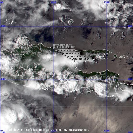
Looking at the RGB visible composite above isn’t very conclusive other than showing some high level fuzz from an anvil being driven by the jetstream. Let’s look at the channel 13 data which shows us the cloud top temperature:
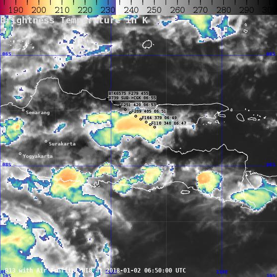
The B13 image is grayscale from warm temperatures to -42C, below which it is commonly accepted that convective development must be present. We can then see that the storm on the upwind side shows temperatures well below -70C, a decent intensity cumulonimbus by the looks of it.
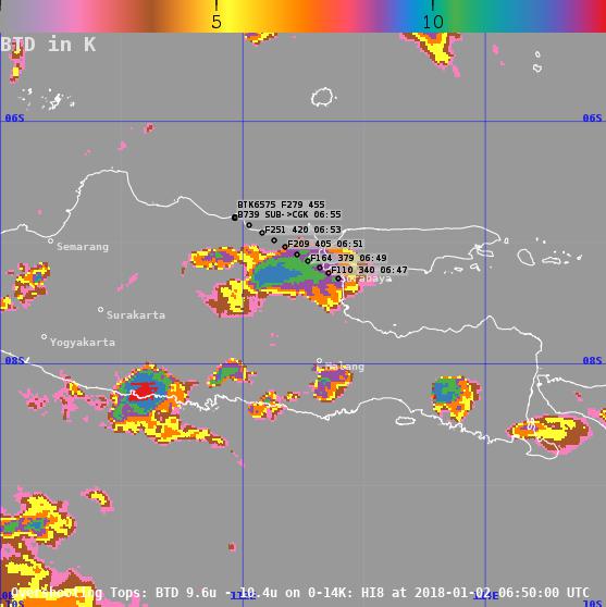
Finally, a useful image in the analysis of severe weather is the “overshooting tops” image above. This shows the temperature difference between two channels, and is indicative of how severe the updrafts are inside a cell. The larger the temperature excess, the stronger the updraft. This shows an excess of more than 11 K where the flight has passed through. That is indicative of significant convective development and probably the reason for the turbulence encounter. CAT is an unlikely contender.
One wonders whether this storm painted on the weather radar, whether the weather radar was working and being used correctly, and why a wider berth was not given to this storm. It is common practice to deviate by at least 40NM downwind from a CB, not just because of turbulence, but also because hail often is blown out the top of these storms. In this particular case this would have added maybe 5 – 8 minutes of flight time.
